Research Team: Nancy England, MESc. Student, April James, Krys Chutko (faculty, Dept. of Geography, Nipissing University), Rich Pyrce, Ministry of Natural Resources – South Porcupine.
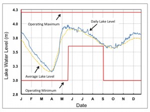
The Sturgeon River watershed is a ~7000 km2 area generating a major inflow to Lake Nipissing and is home to valuable and diverse resources including recreational (e.g. Lake Temagami), agricultural production and hydropower generation. Water levels in Lake Nipissing are managed to minimize risk to flooding, maintain ecosystem and fisheries health and support recreational activities.

Water levels in Lake Nipissing are managed to managed to minimize risk of floods, meet ecological requirements and support recreational activities.
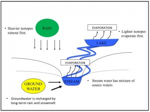
Challenges in managing river and lake levels come from uncertainties in monthly and daily rainfall, and snowpack accumulation and melting during springtime. In 2013, we began a study of the Sturgeon River watershed to examine the sources of riverflow using water isotopes. Our aim is to inform future management practices by improving our understanding of the relative influences of rainfall, snowmelt, lake and groundwater inputs to river flow across this large watershed.
Riverflow and major adjacent lakes were sampled biweekly from January-December, 2013. Snowpack and snowmelt samples were collected during winter and rainfall through the rest of the year. Local residents of the watershed volunteered their private wells to sample groundwater (purged through their existing residential water system).
Analysis of samples for water isotopes (oxygen and hydrogen) is ongoing in the Department of Geography at Nipissing University. These data will be combined with information on river flowrates to understand how snowmelt influenced river flow during the 2013 spring freshette and how lake and groundwater contribute through the rest of the year.


